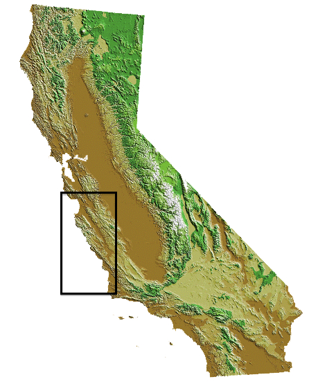
The Central Coast region extends from Santa Cruz County south along Monterey Bay and the isolated Big Sur coast in Monterey County, to Morro Bay and Avila in southern San Luis Obispo County. Historically, much of the seafood caught in this area was landed at Monterey, where the sardine and salmon industries boomed from the late 1800s to the mid-1900s. By 1950, 25 sardine canneries operated along Monterey’s Cannery Row, with and another 14 at Moss Landing. The fishery collapsed shortly thereafter, shifting effort to other fisheries and areas. Commercial ocean salmon fishing is also credited as developing in Monterey Bay. Today, fishermen continue to target coastal pelagic species (anchovy, sardine and squid) and salmon, along with groundfish and other species.
Fishing communities
This region encompasses three counties with five primary port-based fishing communities (listed north to south):
| Santa Cruz County | Monterey County | San Luis Obispo County |
| Santa Cruz | Moss Landing | Morro Bay |
| Monterey | Avila/Port San Luis |
Types of local commercial fisheries
In recent years, the Central Coast region has supported a variety of fisheries, with sablefish, sardine, squid and salmon among the most active. However, the mix of fisheries and level of activity in each port and overall varies as a function of changes in species distribution and availability, regulations, physical infrastructure, market demand, buyers and other factors.
In 2013, commercial fishermen landed more than 53.8 million pounds (24,400 metric tons) of seafood in this region with an ex-vessel value (amount paid to fishermen) of nearly $26 million. The top fisheries (species-gear combinations, listed in alphabetical order) in pounds landed and/or ex-vessel value that year were:
See our regional seafood posters and the commercial fishery landings data (links below) to learn more about the fisheries of this region.
| Ex-Vessel Value (≥ $1 million each) | Pounds landed (≥1 million pounds each) |
|---|---|
| Blackcod (sablefish) hook-and-line, trap, trawl | Blackcod (sablefish) hook-and-line, trap, trawl |
| Dungeness crab pot | Coastal pelagic finfish (anchovy, sardine) seine |
| Groundfish (rockfish, flatfish) hook-and-line, trap, trawl | Groundfish hook-and-line, trap, trawl |
| Market squid seine | Market squid seine |
| Salmon (Chinook or king) troll |
Fisheries seasonality
The chart below shows the times when the major commercial fisheries of the Central Coast region are most active. Other, smaller fisheries, while also important, are not shown here. This chart combines all gear types that target the indicated species. Note that fishing activity does not necessarily start at the beginning or stop at the end of a month, and that the timing and types of fisheries may vary from year to year. (See state and federal commercial fishing regulations for current and specific dates.)
Seasonality of selected Central Coast California fisheries in 2013

Note; Seasonality is based on 2013 regulations, resource availability off California's Central Coast, and market demand, and may vary from year to year due to those and other factors. Some fisheries use multiple gear types and/or target multiple species. *Coastal pelagic finfish species **Groundfish species
The local ocean environment
The Central Coast region's ocean environment is a highly productive upwelling-driven ecosystem that contains many unique features such as:
- Giant kelp forests
- Monterey Submarine Canyon
- Bays and estuaries (e.g., Elkhorn Slough, Morro Bay)
Ocean waters within the region have both soft-bottom (sand and/or mud) and rocky habitats, including pinnacles, outcrops and canyons, with all of them important for certain fisheries. The extent extent of the continental shelf varies: off Big Sur, it is narrow and drops off sharply to deep water, while off Morro Bay, it is broader, with extensive soft-bottom habitat.
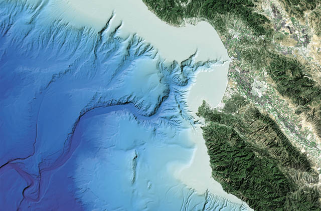
One of the most remarkable features in the area that contributes to the high marine biodiversity of the region is the mile-deep Monterey Submarine Canyon, which begins less than 100 yards off the coast near Moss Landing and extends about 95 miles southwest along the ocean floor. The canyon's depth and nutrient flows provide extensive habitat for a remarkable variety of marine life, from deep-sea worms to giant blue whales.

Bathymetry (underwater topography) of the Monterey Submarine Canyon. Credit: Monterey Bay Aquarium Research Institute
The management context
The region's commercial fisheries are managed by the state through the California Legislature, the Fish and Game Commission and the Department of Fish and Wildlife (CDFW); by the federal government through the Pacific Fishery Management Council (PFMC) and National Marine Fisheries Service (NMFS); or by both (see Management Context for more information). The following table shows which government entity (or entities) has management authority and the management measures used for some of the region’s most active fisheries.
| Fishery | Management Authority | Management Measures | |||||
|---|---|---|---|---|---|---|---|
| State | Federal | Limited entry | Quotas | Time/area closures | Species size/sex rules | Gear restrictions | |
| Albacore troll |
✓ |
✓ |
|||||
| Blackcod (sablefish) hook-and-line, trap, trawl | ✓ | ✓ | ✓ | ✓ | ✓ | ✓ | ✓ |
| Coastal pelagic finifish seine | ✓ | ✓ | ✓ | ✓ | ✓ | ✓ | |
| Dungeness crab pot | ✓ | ✓ | ✓ | ✓ | ✓ | ||
| Groundfish hook-and-line, trap, trawl | ✓ | ✓ | ✓ | ✓ | ✓ | ✓ | ✓ |
| Market squid seine | ✓ | ✓ | ✓ | ✓ | ✓ | ||
| Salmon troll | ✓ | ✓ | ✓ | ✓ | ✓ | ✓ | ✓ |
Note: Management authority and/or measures may vary for a given fishery depending on species and/or gear type
Information Sources
- California Marine Life Protection Act Initiative (CA MLPAI). 2005. MLPAI Regional Profile of the Central Coast Study Region (Pigeon Point to Point Conception, CA), September 19, 130 pp.
- Hackett, S. 2002. An Economic Overview of the California Wetfish Industry Complex. In California's "Wetfish" Industry: It's Importance Past, Present and Future, edited by D. Pleschner-Steele. Santa Barbara, CA: California Seafood Council, 65 pp.
- Leet, W.S., Dewees, C.M., Klingbeil, R. and E.J. Larson. 2001. California's Living Marine Resources: A Status Report. 4th ed. Sacramento, CA: CDFG, 562 pp.
- Pomeroy, C., M. Hunter and M. Los Huertos. 2002. Socio-Economic Profile of the California Wetfish Industry. In California's "Wetfish" Industry: It's Importance Past, Present and Future, edited by D. Pleschner-Steele. Santa Barbara, CA: California Seafood Council, 46 pp.
- Pomeroy, C. & M. Dalton. 2005. Market Channels and Value Added to Fish Landed at Monterey Bay Area Ports. Research Final Report, California Sea Grant College Program, 18 pp.
- Pomeroy, C., and M. Dalton. 2003. Socio-Economics of the Moss Landing Commercial Fishing Industry. Report to the Monterey County Office of Economic Development and the Moss Landing Study Steering Committee, 121 pp.
- Pomeroy, C. and M. Stevens. 2008. Santa Cruz Harbor Commercial Fishing Community Profile. California Fishing Communities Project. University of California Sea Grant College Program T-066, San Diego, CA, 34 pp.
- Scofield, W.L. 1954. California Fishing Ports. Fish Bulletin 96. State of California, Department of Fish and Game, Bureau of Marine Fisheries, 159 pp.
- Starr et al. 2002. Trends in Fisheries and Fishery Resources Associated with the Monterey Bay National Marine Sanctuary from 1981-2000. Sea Grant College Program, La Jolla, CA, 156 pp.
CDFW Commercial Landings Information
Monterey Bay National Marine Sanctuary
NMFS Commercial Fisheries Statistics
Pacific States Management Fisheries Commission (PSMFC) Pacific Fisheries Information Network (PacFIN)
